
 Алгебра
 Английский
 Биология
 География
 Геометрия
 История
 Русский
 Обществознание
 Физика
 Химия
Химия Информатика
 Литература
 Математика
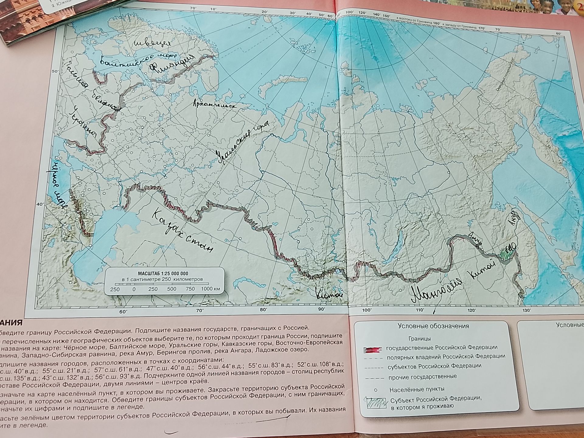
Please identify the countries bordering Russia on the map and label the geographical features that form the border of Russia: Black Sea, Baltic Sea, Ural Mountains, Caucasus Mountains, East European Plain, West Siberian Plain, Amur River, Bering Strait, Angara River, Lake Ladoga. Also, label the cities located at the following coordinates: 40° N, 55° E; 55° N, 21° E; 57° N, 61° E; 47° N, 40° E; 56° N, 44° E; 55° N, 83° E; 52° N, 108° E; 60° N, 135° E; 43° N, 132° E; 56° N, 93° E. Underline the names of cities that are capital republics with a single line and the names of cities that are regional centers with a double line. Mark the settlement where you live on the map. Color the territory of the subject of the Russian Federation where it is located. Circle the borders of the bordering subjects of the Russian Federation and label them with numbers. Color the territories of the subjects of the Russian Federation where you have been with green and label them in the legend.
Ответ:
Analysis of the Map and Instructions:
The provided image is a map of Russia with handwritten labels and instructions in Russian. The instructions ask to identify bordering countries, label geographical features that form Russia's border, locate and label cities based on coordinates, and mark personal locations and visited regions. However, as an AI, I cannot interact with the map visually, nor do I have personal location data or the ability to "mark" or "color" areas on an image.
Therefore, I will focus on the parts of the request that can be addressed through text and general knowledge, which are identifying bordering countries and geographical features, and providing city names based on coordinates, assuming the coordinates are within Russia.
Bordering Countries of Russia:
- Norway
- Finland
- Estonia
- Latvia
- Lithuania
- Poland
- Belarus
- Ukraine
- Georgia
- Azerbaijan
- Kazakhstan
- China
- Mongolia
- North Korea
Geographical Features Forming Russia's Border:
- Black Sea (South)
- Baltic Sea (West)
- Ural Mountains (East, separating European Russia from Asian Russia)
- Caucasus Mountains (South)
- East European Plain (Partially forms the western border)
- West Siberian Plain (Mostly within Russia, does not form a significant border feature in the context of the instructions)
- Amur River (Forms part of the border with China)
- Bering Strait (Separates Russia from the USA)
- Angara River (Inland river, not a border feature)
- Lake Ladoga (Inland lake, not a border feature)
Cities at Specified Coordinates (Approximations within Russia's assumed territory):
- 55° N, 21° E: Kaliningrad (Russia's exclave)
- 56° N, 44° E: Kazan (Capital of Tatarstan)
- 55° N, 83° E: Novosibirsk (Major city in Siberia)
- 52° N, 108° E: Irkutsk (Near Lake Baikal)
- 60° N, 135° E: Yakutsk (Capital of Sakha Republic)
- 43° N, 132° E: Vladivostok (Port city in the Russian Far East)
- 56° N, 93° E: Krasnoyarsk (Major city in Siberia)
- 47° N, 40° E: Likely within Russia, near the Caucasus region, could be near Makhachkala or Grozny.
- 57° N, 61° E: Likely within Russia, near the Ural region, could be near Yekaterinburg.
- 40° N, 55° E: Likely within Russia, near the Caucasus region, could be near Astrakhan.
Note: Identifying the exact cities without a more detailed map and precise coordinate system is challenging. The listed cities are based on general geographical knowledge of Russia.
Regarding the specific instructions for underlining cities and coloring territories: These actions require direct interaction with the image, which is beyond my current capabilities. I can identify the information, but I cannot modify or annotate the image.
Regarding marking personal location and visited regions: I do not have personal information such as where I live or places I have visited. This part of the task is not applicable to me.
