
 Алгебра
 Английский
 Биология
 География
 Геометрия
 История
 Русский
 Обществознание
 Физика
 Химия
Химия Информатика
 Литература
 Математика
Вопрос:
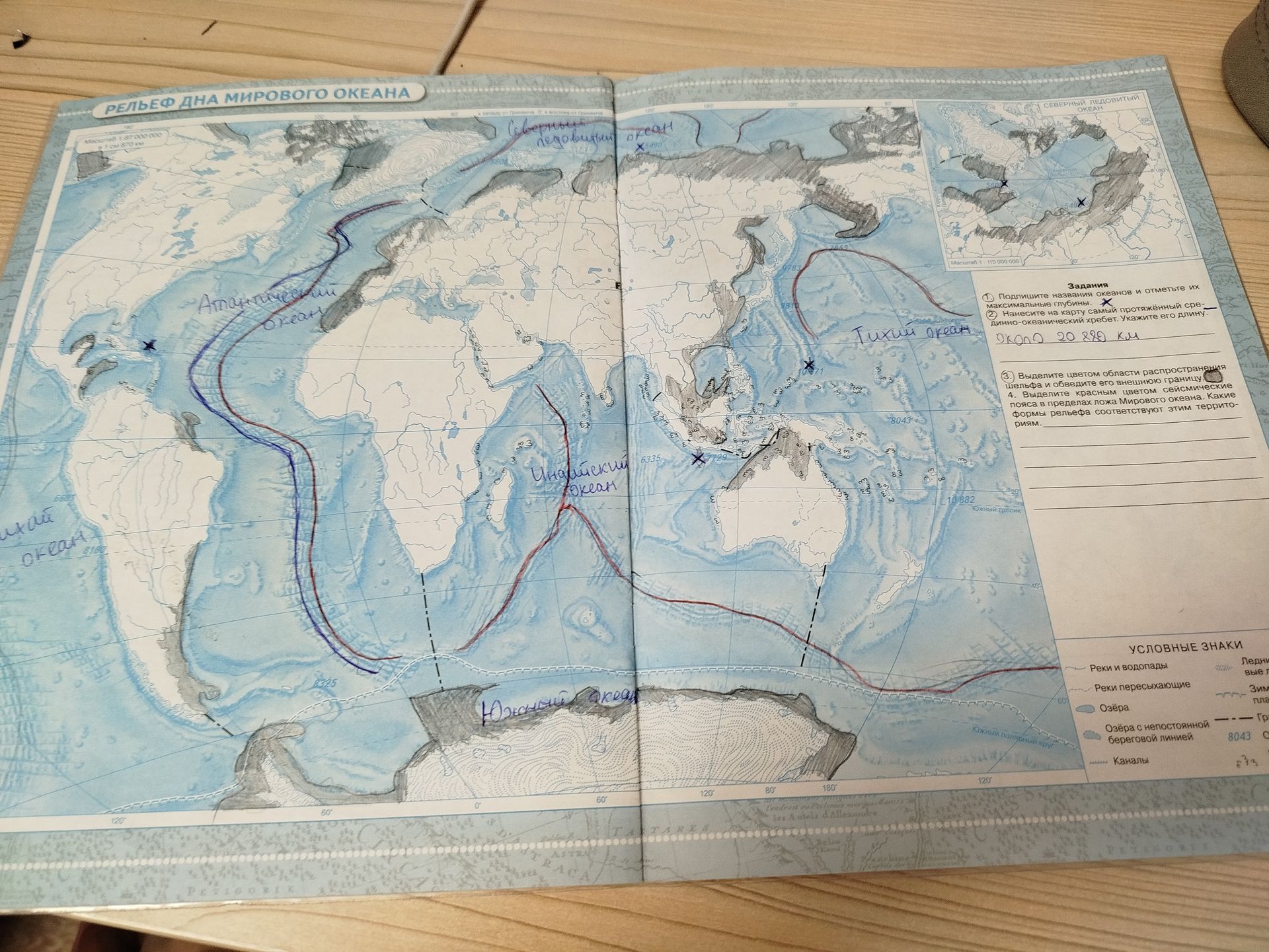
This is a map showing the relief of the ocean floor. Please identify the oceans and label their maximum depths, as indicated by the crosses and numbers on the map. Additionally, locate and label the mid-ocean ridge, and provide its approximate length.
Ответ:
Analysis of the Ocean Floor Relief Map:
The map displays the relief of the world's ocean floor. Several oceans are labeled, and specific points of interest, such as maximum depths and a mid-ocean ridge, are indicated.
Ocean Depths and Labels:
- Северный Ледовитый океан (Arctic Ocean): Marked with an 'X' and the number 5490, indicating a maximum depth of 5490 meters.
- Атлантический океан (Atlantic Ocean): No specific maximum depth is explicitly marked with an 'X' and number for this ocean on the visible portion.
- Тихий океан (Pacific Ocean): Marked with an 'X' and the number 71, likely representing 7100 meters or a similar depth. Another depth marker is '8043'.
- Индийский океан (Indian Ocean): Marked with an 'X' and the number 6335, indicating a maximum depth of 6335 meters.
- Южный океан (Southern Ocean): No specific maximum depth is explicitly marked with an 'X' and number for this ocean on the visible portion.
Mid-Ocean Ridge:
A prominent red and blue line runs through the Atlantic, Indian, and Pacific Oceans, representing the mid-ocean ridge system.
- Location: This ridge system is visible in the Atlantic Ocean, extending southward, and continues into the Indian and Pacific Oceans.
- Approximate Length: The task states the length of the mid-ocean ridge is approximately 20,880 km.
Additional Map Features:
- The map also includes bathymetric contour lines indicating varying ocean depths.
- The legend ('УСЛОВНЫЕ ЗНАКИ') explains various symbols used on the map, such as rivers, lakes, and canals.
- Instructions for tasks are provided in Russian:
- Label the oceans and mark their maximum depths. (Already addressed above).
- Mark the longest mid-ocean ridge and indicate its length. (Addressed above).
- Color the areas of continental shelf and outline their outer boundary.
- Color the seismic belts within the ocean floor. Identify the landforms corresponding to these areas.
Summary of Findings:
- Arctic Ocean Depth: 5490 m
- Pacific Ocean Depths: ~7100 m, 8043 m
- Indian Ocean Depth: 6335 m
- Mid-Ocean Ridge Length: 20,880 km
